Jump to navigation

The University of Arizona Wordmark Line Logo White
Home
  • BE Facebook
  • BE Twitter
  • College of Agriculture & Life Sciences
  • College of Engineering
  • Undergraduate
    • Biosystems Engineering, BS
    • Biosystems Analytics & Technology, BS
    • Pre-Health Track
    • Admissions
    • Course Descriptions
    • Directed Research & Independent Study
    • Funding Opportunities
    • Graduation Requirements
    • Internships
    • Student Organizations
    • Transfer Credit
    • Academic Program Assessment
    • Job Opportunities
    • Resources For Students
  • Graduate
    • Biosystems Engineering, MS & PhD
    • Biosystems Analytics & Technology, MS & PhD
    • Admissions
    • Course Descriptions
    • Funding Opportunities
    • Grad Research Features
    • Job Opportunities
    • Student Organizations
    • Resources for Students
  • People
  • Research
    • Biometry & Biosystems Informatics
    • Controlled Environment Agriculture
    • Food, Bioproducts, & Renewable Energy
    • Precision Agriculture
    • Water Resources
  • Extension
    • Controlled Environment Agriculture
    • Precision & Mechanized Ag
    • Water Resources
  • Department
    • About
    • History of BE
    • Facilities
    • Shantz 440
    • Business Center
    • Employees
    • Origins and Destinations
    • New Faculty Resources
    • Faculty Teaching Resources
  • Support BE
  1. Home
  2. Research
  3. Precision Agriculture
  4. Precision Ag with Drone Technology

Precision Ag with Drone Technology


YUMA and MARICOPA, AZ –Precision Agriculture with Drones

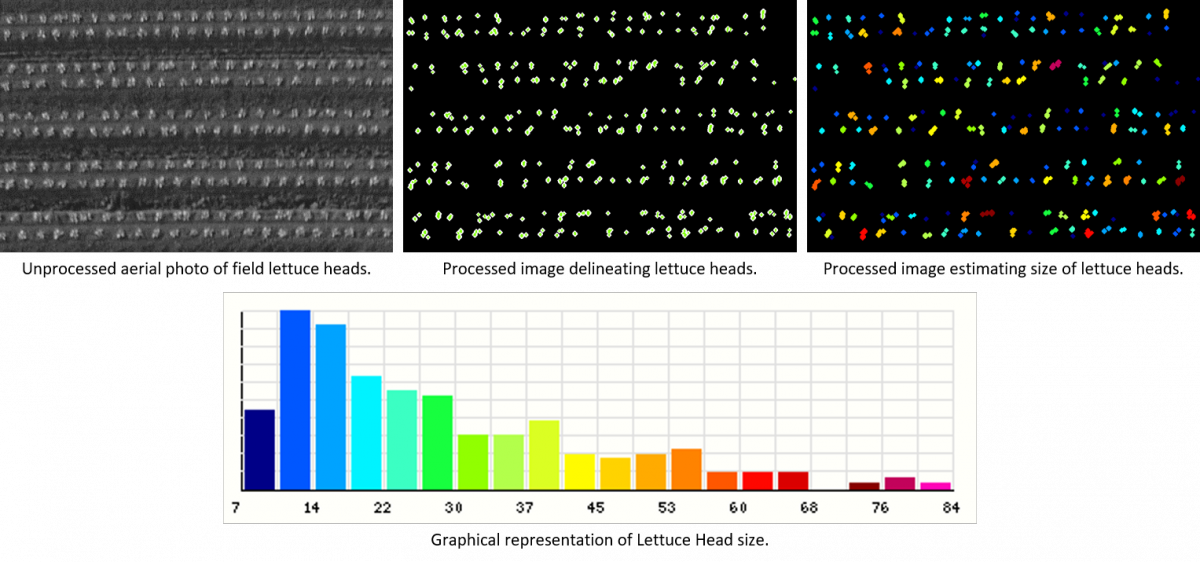
Using drones equipped with sensors and other imaging technologies, BE is collaborating with scientists at Yuma and Maricopa Ag Centers to develop simple and near-real time tools to assist farmers  control and manage  field crops.  Drones offer a costs effective alternative to satellite imaging that essentially mimics satellites but with many folds the precision and ease of deployment.  They capture the spectrums of light invisible to the naked eye and measure the crop development with higher precision and submillimeter resolution.


With this multi-spectral, thermal, and other  data collected from drones, famers are able to:

  • Measure plan size and  monitor their growth  for more accurate predictions of crop demand and yield.
  • Differentiate weeds from the actual crop (ex: lettuce), so that they can be targeted and removed (via human labor or automated machinery) to optimize crop growth and resource allocation.
  • Monitor crop  health in near-real time, so that farmers can take appropriate actions.
  • Estimate  irrigation water needs based on plants stress and field ET and  optimize efficiency further.


Research

  • Biometry & Biosystems Informatics
  • Controlled Environment Agriculture
  • Food, Bioproducts, & Renewable Energy
  • Precision Agriculture
    • Precision Ag with Drone Technology
    • TERRA REF Scanalyzer
  • Water Resources

1177 E. 4th Street, Shantz Building, Room 403, Tucson, AZ, USA 85721-0038 be-info@arizona.edu (520) 621-3691


We respectfully acknowledge the University of Arizona is on the land and territories of Indigenous peoples. Today, Arizona is home to 22 federally recognized tribes, with Tucson being home to the O’odham and the Yaqui. Committed to diversity and inclusion, the University strives to build sustainable relationships with sovereign Native Nations and Indigenous communities through education offerings, partnerships, and community service.

User login

  • Request new password

University Privacy Statement

© 2023 The Arizona Board of Regents on behalf of The University of Arizona.